Our Vision
Sustainable development and productive public serviceOur Mission
To uplift lives of people in the region through an efficient,sustanable and planed development process with the provision of services in compliansce with the state polices, coordination of the resources and participation of the public.Introduction Of The Division
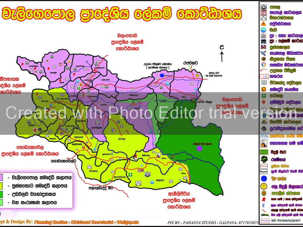
This division is bordered by the Balangoda divisional secretariat to the north, Embilipitiya and Godakawela divisional secretariats in the south, Godakawela and Opanayaka divisional secretariats in the west, Balangoda kolthota divisional secretariat in the east.
Land area - 163.98 square kilometers.
Number of Grama Niladari Divisions - 30
Number of villages - 175
There is only the Weligepola Divisional secretariat as the head office of the Government. The following institutions also contribute to the development work of the Weligepola Divisional Secretariat Division Landscape
There are three main mountain terraces in the North-East-North-East area of the division.
1. Panana Mount
2. Ranwala mountain range
3. Dalukgala mountain range
The mountain range, the Medaganoya mountain range, the Kottibulwala Kahangala mountain range and the Panana mountain range are situated in the Weligepola Divisional Secretary's Division in the North-East-North-East. The average height of the mountain ranges is between 1000 and 3000 meters. As a whole, the total area is about 70% of the total area.
The Dalukgala mountain in this area shows two very important characteristics. Among them are topography such as crests, slopes and slopes. They can be seen as the plains in the South, South-East divisions. The plains represent 30% of the total land area
All in all, the geographical region of the region is found in the southeastern and northwestern parts of the mountain range and similar elevations. There are many valleys due to the high altitude of the northwest. The mouths such as Katupaththa Oya and Kudu Oya begin with these rivers and these areas are located on the southeast Pusathota, Galpaya, Muthtethtupola and Bambaragala. The Balabaragala Mountain Reserve Mountains are examples.
Climate
There are dry and dry climate in the southeast and eastern parts of the division. Also, the North and Northwestern regions show wet weather. According to the location of the site, it is evident that the climate pattern changes from the southeast to the northwest. The annual rainfall also varies. Similarly, 1500 mm in the north-eastern region and 2000 mm in the northwestern part of the country are also found in the rainfall. .
On the whole, throughout the year, there is high temperature, but the high temperature in the southeastern region is high. The average annual temperature is between 25-35 ° C. As in the area, there are several changes here. From the sands and the rainfall, the temperature from southeast to northwest
There is a decrease in the Northwestern part of the country. There is an increase of showers in the Northwestern parts and there is a decrease in the temperature in these areas. This is due to the leftover forests. is.
Draining
There are two main rivers in the area.
1 .Katupath Oya
2. Kuda oya
The main streams of Kuda Oya begin from Medaganoya in Ranwala. The Medanangoya is also passing over several Grama Niladhari Divisions and joining to the Udawalawa reservoir.
Katupath Oya that starts from the flora of the Katoutaka Oya is connected with several other tributaries and traverses along Hapugiriya, Kapugala and flows into the river of the river Walawe. There are few small streams in this area as well.
1 .Elamalpe Oya
2 .Madangaoya
3 .Meegammantha Oya
4 .Wedage oya
5 . Ratmal Oya
These are some of them.
Apart from this, there are also several small tanks spread across the area.
1.Ranwala tank
2.Ambalawa tank
3.Malakadura tank
4. Pulugahawela Tank
5. Konkatuara tank
6.Weligepola tank
Soil
There are five different types of soil in this division. Green soil, red soil, sand soil, clay soils and gravel soil are important in this division. Especially the areas of the gravel and red soil in the North and Northwestern areas are most visible . There are many clay soils (Thalagaskanda, Ambalvila, Pussathota) in the middle of the area (Thalagaskanda, Ambalvila, Pussathota). The soil and the low temperature are high in Handrigiriya, Handirigoda, Magayaya Galpaya, Pusthotota and Muththettapala .
The fertility of the soil varies according to the physical location. The soil in the North is less fertile. Chen cultivation, tea cultivation and so on cause the soil to wash away. Therefore, landslides in some parts of the hill area have also been caused by erosion. However, the area is fertile in the south-south-east of the area. The heavy rainfall is not received in these areas.
Soils are also affected by soil erosion, as well as soil erosion. Especially in the north-western areas, soil erosion has increased due to the higher elevation of the soil, and the soil washed more water for the ravages of the tea grass. Also, water conservation is also very low due to clearing of forest lands. Therefore, conservation of this area should be done in a more systematic manner. Alternatively, Ilukkubura can be described as eroded areas.
Natural vegetation
All natural forests in this division can be referred to as secondary forests. These natural forests that have been destroyed after the destruction of the original forests also face threats of destruction. It is evident from the following figures.
• Ammaduwa Mukalana -110 acre
• Panana mountain range - 57 acre
• Kadigala Mukalana -81 acre
• Bambaragala Acres -82 acre
• Dadakara Mukalana - 51 acre
In terms of population density, forest cover is clearly seen. Surface and temperature are also very favorable for increasing natural vegetation. These are often the tops of trees at the top of the trees. There are some kinds of undergrowth in some kind of tree. In this forest, , hora, Kaluwara, Buruta, nellie, khomba and trees are good.
The main sources of income
High quality fields are found in highlands, tea, rubber cultivations are available and coconut and paddy fields are used in lowland areas. Dried fruits and vegetables are grown in the dry season with an arid climate. Agriculture is the livehood of many in the area. It has two parts.
Export agriculture
Consumer agriculture
The areas to be exported are North Western (North) areas, which are cultivated with tea, rubber and coconut. Coconut cultivation is a major cultivation of these cultivations. It is 8104 acres. There are 485 acres of rubber and 2955 acres of tea in the area. Since there is no factory for tea in the area, they sell the leaf leaf to private traders.
Although coconut is cultivated more than other crops, it is not possible to see such large coconut estates in extent of 50 acres. However, coconut can be used for various purposes. Of these, part of this is utilized and the rest is sold to the market. Sale of fruits, Production of coconut husks, sale of coconut shell charcoal and minor coir production were also done in the area Bei. There is a good demand for these, but there are no transport facilities available to bring the product to the market.
There are 1968 acres of paddy cultivation for paddy cultivation in the Weligepola Divisional Secretariat. However, due to lack of water, the entire cultivation is not cultivated. Due to various reasons, these paddy lands are cultivated with minor irrigations and sky water. But the yield is very limited. There are several reasons.
1. Water shortage
2. The use of traditional methods
3. Reducing the use of technology and fertilizer
These are among the most important.
Besides this, the consumer agriculture is important in the agriculture of agriculture, vegetables and fruit cultivation. It is important to use cowpea, green gram, kurakkan, tala, millet, corn and yam. Balcony plantations are very popular in Ambalvila and Badullaegama areas.
These are carried out as an agrochemical industry. The above crops are cultivated in Muthtethtupola, Galpaya, Magayaya and Pussatota in the arid climate.
Vegetable cultivation has been successfully cultivated in areas such as Handiriga, Muththettupola, Galpaya, Pussatota, and Pollamura in areas dry with dry climate. Every vegetable growing in the country is well cultivated in these areas. In the recent past, gherkins were found in the Handagiriya area. Red onion, peanuts and tobacco in these areas are very well cultivated, and these are grown to be mainly marketed.
Banana is the most common crop in the area. It's been cultivated by farmers as a home gardening business. But the only weakness here is the low-cost sugar plantation. This kind of banana is not so easy to eat. Bananas are not much interested in planting other varieties. Other kinds of mango are mango, papaya, and lime. These are being done as gardening.
Generally speaking, there is a lack of facilities for bringing the products of the product to the market and lower prices for their products. There are many reasons. There are fewer available transport facilities available for traders at the required price. Therefore, a competitive price No price will be given to the farmers. Minor traders also add and sell the farm. It is also evident that the intermediary merchant is richer, as there are no payouts to the farmers at all times.